MRP: Bishop's Palace
Dallison family house, Bishops palace (or place), Halling, Kent, also known as Halling Hall
Editorial history
25/12/11, CSG: Added hyperlinked Table of Contenty
THIS ENTRY REQUIRES EDITING
Contents
Suggested links
See Places
See House in St. John Street, Clerkenwell
To do
Location
The Bishop's palace or place, also known as Halling Hall, lay in the centre of the village of Lower Halling off what is now called Ferry Road. It bordered the western bank of the River Medway, and overlooked the Wouldham marshes to the east and south. A ferry linked the two banks of the Medway at this point, where the modern river is particularly narrow, as it turns with a sharp kink on the way from Snodland towards Chatham, Strood and Rochester. The surrounding land was not of high quality, being largely marshland, and, at higher levels, of chalk
The topographer William Ireland, published in 1830, commented on the unhealthy situation of Lower Halling in comparison with the nearby village of Upper Halling, which was built on higher ground half a mile further west. He suggested that the place was rendered "far from healthy and pleasant" as a result of the quantity of salt and freshwater marshland which lay between the chalk uplands and the river Medway.[1]
Francis Grose, published in 1782, preferred the name Halling hall over the Bishop's palace, and was more positive about the location, suggested that the name of Halling signified in Saxon "the wholesome low place or meadow." He stated that it was one of four houses belonging to the bishops of Rochester and was "pleasantly situated on the western banks of the river Medway, about three miles south of Rochester."[2]
The parish of Halling was a small parish, with Ireland reporting in 1821 only fifty dwellings and three hundred and forty-sixparish inhabitants.[3]
Building
It is clear that the buildings were in somewhat poor condition by the early seventeenth century, and that they deteriorated further in following century.
Several early seventeenth century Chancery documents comment on the poor condition of the buildings of the Bishop's palace.[4] Ireland stated that in 1715 "a great part of the ruins remained, viz. the chapel, the hall, and a gate, with the arms of the see of Rochester in stone; in which state the fabric continued till within memory, but has since been destroyed for the sake of the materials."[5] He appears to have paraphrased Harris' comments on the buildings, which were actually published in 1719 according to Grose.[6] Grose published an engraving subsequently reproduced elsewhere, which he wrote reflected the state of the buildings in 1759.[7]
Halling House, Kent, Grose, 1784 (reflecting 1759)
Halling House, Kent, Grose, 1784[8]

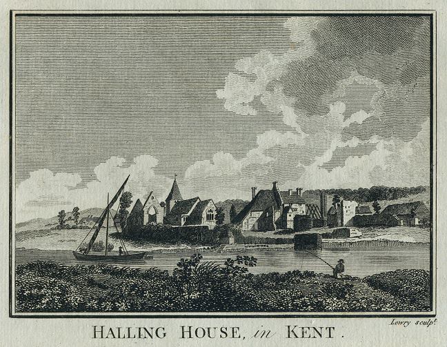
Halling Hall, Kent, Lowry, 1786
Halling Hall, Kent, Lowry, 1786[9]

Halling Palace, East View, 1783

Bishop's palace link to Dallison/Dalyson family
The Bishop's palace or Halling hall came into the Dalyson family through the marriage of the lawyer William Dalyson to Silvester Dene of Halling. On the death of Silvester's father the lease came to William Dalyson. William predeceased Silvester, who married again to a fellow lawyer, William Lambarde, known also for his early county history of Kent. Lambarde resided in Halling until Silvester's death in 1587, when he returned to East Greenwich, and the lease then was transferred to her son, Maximilian, the future Sir Maximilian Dallison, father of Elizabeth's husband, William. Sir Maximilian resided at the Bishop's palace, as did William and Elizabeth, but on the marriage of their son, Maximilian, to Frances Stanley in 1649/50, Maximilian and his wife moved to the Hamptons, Kent, somewhat further west, having leased that property from Frances' father, Thomas Stanley.
A series of chancery records in the first half of the seventeenth century chart the financial problems of the Dallison family as it struggled with the lease on the Bishops palace and associated lands. The palace and lands were held by lease from the Bishop of Rochester.
See [- Map of North Weald Houses]
Image credits
(1) 'Halling House, Kent' in Francis Grose, The antiquities of England and Wales, vol. 3 (London, 1784), plate between pp. 52 & 53
- Source book and engraving are out of copyright
(2) 'Halling House, Kent', engraved by Lowry, published in Picturesque Views of the Antiquities of England & Wales, 1786. Copper engraved print, good condition. Size 17.5 x 13.5 cms including title, plus margins
- Source book and engraving are out of copyright. Digital image is courtesy of - antiqueprints.com and has been made - available for website reproduction on the basis of non-commercial use
Primary sources
BL, MS. 28,000, Letter from Henry Oxinden (?of Barham) to John Warner, Bishop of Rochester, April 17th 1643, f. 243, printed in Dorothy Gardiner, The Oxinden and Peyton Letters, 1642-1670, being the Correspondence of Henry Oxinden of Barham, Sir Thomas Peyton of Knowlton and Their Circle (London, 1937), pp. 14-15
C 2/Eliz/D1/45
C 2/Eliz/D2/45
C 2/Eliz/D5/59
C 2/Eliz/D6/57
C 9/49/48
Secondary sources
Images
Plate of engraving of the ruins of the episcopal palace of Halling, between p. 270 & 271, in W.H. Ireland, England's topographer: or A new and complete history of the county of Kent, vol. 4 (London, 1830)
Plate of engraving of Halling Hall, Kent in Francis Grose, The antiquities of England and Wales (XXXX, 1784), plate between pp. 52 & 53. This plate appears to be an earlier version of the plate engraved by Lowry in Picturesque Views of the Antiquities of England & Wales, 1786
Plate VI. 'East view of the ruins of Halling palace' in John Thorpe, Bibliotheca Topographica Britannia (?London, 1782), vol. VI, pt. 1, between pp. 2 & 3- ↑ This is the footnote text
- ↑ This is the footnote text
- ↑ This is the footnote text
- ↑ This is the footnote text
- ↑ This is the footnote text
- ↑ This is the footnote text
- ↑ This is the footnote text
- ↑ ‘Halling House, Kent’ in Francis Grose, The antiquities of England and Wales, vol. 3 (London, 1784), plate between pp. 52 & 53
- ↑ ‘Halling House, Kent’, engraved by Lowry, published in Picturesque Views of the Antiquities of England & Wales, 1786. Copper engraved print, good condition. Size 17.5 x 13.5 cms including title, plus margins. Digital image is courtesy of http://antiqueprints.com